



District Profile
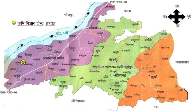
District Map
History
Arwal district is one of the thirty-eight districts of Bihar state, India, and Arwal town is the administrative headquarters of this district.It came into existence in August 2001 and was earlier part of Jehanabad district. Arwal has a population of 699563. The five block divisions are Arwal, Kaler, Karpi, Kurtha and Suryapur Vanshi. Paddy, wheat and maize are the main crops.Nearest airport is at Patna and railway station is at Jehanabad. By road, Arwal is linked with Jehanabad, Patna,Aurangabad and Bhojpur .It’s headquarter is situated at Arwal which is approximately 65 KMs south from the state capital Patna. Arwal town is situated on the right side bank of the river Son, which is a tributary to the river Ganges.
District at a Glance
|
Agro Climatic Zone |
III-B Bihar |
|
Longitude |
84.6688° East |
|
Latitude |
25.164° North |
|
Temperature Maximum |
49.1 °C |
|
Temperature Minimum |
5.8 °C |
|
Geographical (ha) |
62631 |
|
Total cultivable area (ha) |
49520 |
|
Total Net sown area (ha) |
28500 |
|
Area sown more than once (ha) |
5737 |
|
Kharif sown area (ha) |
17188 |
|
Rabi sown area (ha) |
13727 |
|
Summer sown area (ha) |
676 |
|
Gross cropped area (ha) |
31591 |
|
Cropping intensity (%) |
150% |
|
Annual Rainfall (mm) |
1027 |
|
Rainy days |
80 |
|
Total irrigated area (ha) |
26585 |
|
Total rainfed area (ha) |
17100 |
|
Irrigation percent |
60.85% |
|
Soil type |
Clay, Coarse sand |
|
Upland (ha) & % of total cultivable area |
2228.40 ha (4.5%) |
|
Midland (ha) & % of total cultivable area |
42240.56 ha (85.3%) |
|
Lowland (ha) & % of total cultivable area |
5051.04 ha (10.2%) |
|
Soil organic carbon status of the district |
(Low/Medium/High) Medium to Low |
|
Nutrient status of soil of the district |
N (Low/Medium/High) - Low |
|
P (Low/Medium/High) – Medium to low |
|
|
K (Low/Medium/High) – Medium to high |
|
|
Micronutrient status of soil of the district |
Deficiencies in zinc and iron are common, often due to high calcium content in the soil, which can induce micronutrient imbalance. |
|
Fertilizer consumption (Kg/ha) |
202.83 Kg/ha for NPK fertilizers |
|
Total Population |
700843 |
|
Total SC population & (%) of total population |
141314 & 20.16% |
|
Total ST population & (%) of total population |
590 & 0.08% |
|
Male |
363497 |
|
Female |
337346 |
|
Literacy (%) |
57.13% |
|
No of blocks |
05 |
|
No of Panchayat |
65 |
|
No of villages |
511 (Revenue Villages - 325) |
|
Livestock status of the district (based on Livestock Census 2019) |
|
|
Total no. of Indigenous cattle |
50321 |
|
Total no. of cross breed |
20065 |
|
Total no. of Buffalo |
88085 |
|
Total no. of Goat |
37496 |
|
Total no. of Sheep |
1995 |
|
Total no. of poultry |
93044 |
|
Total no. of commercial dairy unit |
10 |
|
Total no. of commercial goatry unit |
5 |
|
Total no. of commercial poultry unit |
500 |
Administration
Arwal district is a part of Magadh division. It came into existence in August 2001 and was earlier part of Jehanabad district.
This District has one subdivision and five blocks ie. Arwal, Kaler, Karpi, Kurtha and Suryapur Vanshi.
This District has two assembly constituency. 214-Arwal,215-Kurtha.It comes under Jehanabad Parlimentry Constituency.
Transport
Nearest airport is at Patna and railway station is at Patna. By road, Arwal is linked with Jehanabad, Patna and Aurangabad and Bhojpur(Through Arwal Sahar Bridge).
Economy
Economy of the district is totally agriculture Based and this area does not have any presence of any Industry. Paddy, wheat and maize are the main crops. Though most of the area of the district is well irrigated but due to lack of infrastructure and power- farmers are not benefitted.